Goals
i-ScubaDiving is investigating the development through advanced technological methods of an innovative system that will offer the possibility remote virtual underwater tour. The aim of the project is:
- To develop innovative services for effective, efficient and remote 3D digitization of underwater landmarks (wrecks, reefs, etc.)
- To offer an exciting "dry" experience underwater diving experience in a virtual reality environment (Virtual Reality/VR) with extra augmented reality information (Augmented Reality/AR) for the spot (e.g. information about the characteristic parts of a sunken ship, etc.).
The i-scubadiving system
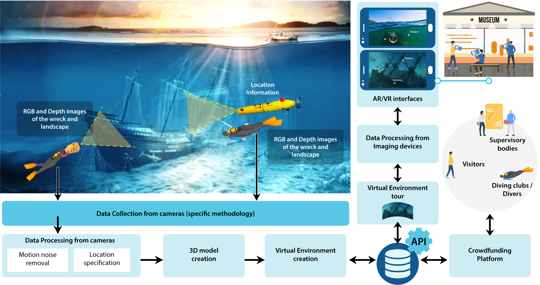
In the context of i-ScubaDiving, a new technological method of three-dimensional (3D) underwater digitization is being developed with the use of common underwater cameras (such as the popular GoPro Action Camera) by amateurs and experienced divers and according with a specific photography methodology, based on the characteristics of the object, the underwater conditions, the camera used and other parameters.
A will be developed crowdsourcing platform, where the users of the system will send the photos and with a remote service and with possibility for feedback they will be able not only to create but also to view the 3D model on a GIS world map. They will also be able to share the model and other related material (eg text, video, photos) with the global diving community and the general non-diving public.
On the platform there will be the possibility to create in virtual and augmented reality environment using libraries and appropriate interfaces that will be developed in the context of the project.
Architecture
The architecture of the i-ScubaDiving system consists of eight (8) main sections:
- Capture photos and location by scuba divers, based on a specific photography methodology that takes into account parameters related to equipment and shooting conditions.
- Processing the collected 2D information from the underwater cameras and analyzing the location and trajectory of the cameras.
- Creation of the 3D 3D model of the underwater point based on image processing, machine learning and computer vision algorithms.
- Creation of the virtual environment in a Unity environment based on the 3D model and data on the marine flora and fauna in the specific marine area.
- Creation of a database with a sophisticated API system, where all the virtual tour data (3D models, virtual environment, 2D photos, etc.) will be stored, as well as the additional information of the users.
- Application of navigation in the virtual environment, where the system will simulate exactly what the user would see if he dived into the site.
- Application for smart devices (tablets & smartphones) that will be activated at specific points of interest and will allow the user to browse the virtual environment remotely.
- Crowdsourcing platform where all data will be displayed on a global georeferenced map.
The graphic representation of the i-ScubaDiving architecture is shown in the figure.